



The streets of central Colombia were filled with their usual rhythm as people headed to work, students attended classes, and businesses welcomed customers. In Bogotá and neighboring communities, it appeared to be another typical morning across one of South America’s most vibrant regions.
Then, without warning, the ground began to move.
Buildings swayed, streets filled with uncertainty, and residents quickly sought safe locations as a strong earthquake rippled through central Colombia. Within moments, emergency services activated response plans while local authorities began assessing infrastructure and coordinating assistance.
Although earthquakes often occur without advance notice, every significant seismic event reminds us of both the immense forces shaping our planet and the remarkable resilience of communities working together during challenging moments.
By examining this event through the perspectives of geology, engineering, psychology, and cultural history, we gain a better understanding of earthquakes and the importance of preparedness in regions located near active tectonic boundaries.
What Happened During the Colombia Earthquake?
According to initial reports, the earthquake measured approximately magnitude 6.3 and originated near Villavicencio, southeast of Bogotá.
While scientists continue evaluating seismic data following significant earthquakes, early information suggested that the event occurred at a relatively shallow depth. Shallow earthquakes generally produce stronger surface shaking because seismic energy travels a shorter distance before reaching populated areas.
Residents across several Colombian cities reported feeling prolonged ground motion, while authorities immediately began inspecting transportation networks, buildings, and public infrastructure.
As with any developing seismic event, official assessments typically continue for days as experts collect additional geological and engineering data.
Why Colombia Experiences Earthquakes
Colombia is located in one of the world’s most geologically active regions.
Several tectonic plates interact beneath northern South America, including the:
Pacific Plate
Nazca Plate
South American Plate
Caribbean Plate
These enormous sections of Earth’s outer crust move continuously, although their movement is generally measured in centimeters per year.
When stress gradually accumulates along geological faults, the stored energy may eventually be released suddenly as seismic waves, producing an earthquake.
This ongoing tectonic activity explains why Colombia experiences periodic earthquakes of varying magnitudes.
The Science Behind Earthquakes
Earthquakes occur because Earth’s crust is constantly moving.
Although the ground appears stable, the planet’s surface consists of interconnected tectonic plates floating slowly above the semi-fluid mantle beneath them.
As these plates shift, they sometimes become temporarily locked along fault lines.
Pressure continues building until the rocks can no longer withstand the accumulated stress.
When that energy is released, seismic waves travel outward from the source in every direction.
These waves cause the shaking people experience during an earthquake.
Scientists study these movements using seismographs that record even the smallest ground vibrations around the world.
Why Earthquake Depth Matters
Magnitude alone does not determine how strongly an earthquake is felt.
Depth is equally important.
Deep earthquakes often lose part of their energy before reaching the surface.
Shallow earthquakes, however, typically generate more intense ground motion because the seismic energy travels a shorter distance.
Population density also influences overall impact.
Even a moderate earthquake may significantly affect a densely populated urban area, while a stronger earthquake in an uninhabited region may produce relatively limited disruption.
For this reason, emergency planners evaluate multiple factors beyond magnitude when assessing potential risks.
Modern Seismology and Early Warning Systems
Advances in earthquake science have greatly improved monitoring capabilities.
Today, networks of highly sensitive instruments continuously record ground movement around the clock.
Although earthquakes cannot currently be predicted with precise timing, many countries have developed early warning systems capable of detecting the first seismic waves.
These systems may provide several seconds of advance notice before stronger shaking reaches nearby communities.
Even brief warnings can allow trains to slow, industrial equipment to stop safely, and individuals to seek protective positions.
Scientists continue improving these technologies through international collaboration and ongoing research.

Engineering for Earthquake Resilience
Modern building design plays a vital role in reducing earthquake risks.
Engineers use specialized construction techniques that allow structures to absorb and distribute seismic forces more effectively.
Common earthquake-resistant features include:
Flexible structural frames
Reinforced concrete
Steel support systems
Energy-dissipating components
Deep foundations
Seismic expansion joints
Building codes continue evolving as researchers gain new insights into structural performance during earthquakes.
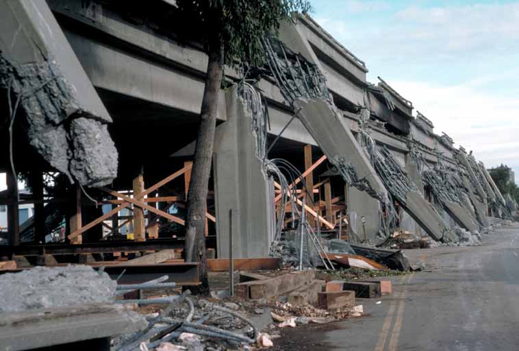
Following major seismic events, engineers carefully inspect buildings to understand how different designs responded to ground movement.
These observations contribute to safer construction practices worldwide.
Emergency Response After a Major Earthquake
Immediately following a significant earthquake, multiple organizations begin working together.
Emergency responders prioritize:
Public safety
Medical assistance
Infrastructure inspections
Transportation management
Utility restoration
Communication with residents
Municipal agencies also evaluate roads, bridges, schools, hospitals, and public buildings before allowing normal activities to resume.
These coordinated efforts help communities recover while minimizing additional risks.
Prepared emergency planning remains one of the most effective ways to strengthen resilience in earthquake-prone regions.
The Psychological Impact on Communities
Earthquakes affect more than physical structures.
Unexpected natural events can temporarily change how people perceive familiar places.
Environmental psychologists describe this connection through the concept of place attachment, the emotional bond individuals develop with neighborhoods, homes, schools, and workplaces.
Following an earthquake, residents often experience heightened awareness when returning to affected locations.
Fortunately, research shows that communities frequently recover through shared support, open communication, and the gradual return of everyday routines.
Schools reopen.
Businesses welcome customers.
Neighbors assist one another.
These ordinary activities play an important role in restoring confidence.
Earthquakes in History and Cultural Traditions
Long before geology became a scientific discipline, civilizations sought explanations for earthquakes through mythology and storytelling.
Many cultures imagined that giant animals, powerful spirits, or legendary beings lived beneath the Earth, causing the ground to shake when they moved.
These stories reflected humanity’s attempt to understand natural forces that seemed mysterious and unpredictable.
Today, geology provides evidence-based explanations through plate tectonics, fault mechanics, and seismic monitoring.
Even so, historical traditions remain valuable cultural expressions illustrating how societies throughout history responded to extraordinary natural events.
Together, science and history deepen our appreciation for both Earth’s dynamic processes and humanity’s enduring curiosity.
Why Preparedness Matters
Although earthquakes cannot currently be prevented, preparedness can significantly improve safety.
Experts commonly recommend:
Knowing safe shelter locations inside buildings
Securing heavy furniture
Preparing emergency supply kits
Creating family communication plans
Following guidance from local emergency authorities
Participating in community preparedness programs
Education remains one of the most effective tools for reducing earthquake risks.
Communities that regularly practice emergency procedures often respond more confidently during actual events.
Scientific Research Continues
Every significant earthquake provides valuable scientific information.
Researchers analyze:
Fault movement
Ground deformation
Seismic wave propagation
Building performance
Soil behavior
Aftershock patterns
Satellite observations
These studies help scientists improve hazard maps, engineering standards, and emergency planning strategies.
International cooperation allows researchers from many countries to share data, leading to continued improvements in earthquake science.
A Reflection on Human Curiosity and Resilience
The earthquake that affected central Colombia serves as a powerful reminder that Earth is a dynamic planet shaped by continuous geological processes. Although seismic events can temporarily disrupt daily life, they also demonstrate the remarkable ability of communities, scientists, engineers, and emergency professionals to work together toward recovery.
Scientific research allows us to better understand the forces operating beneath our feet, while careful planning helps reduce future risks. At the same time, stories shared across generations remind us that humanity has always sought meaning when confronted with nature’s immense power.
Our curiosity drives us to investigate, learn, and improve. Every advancement in geology, engineering, and emergency preparedness represents another step toward safer, more resilient communities. By combining scientific knowledge with cooperation, education, and thoughtful planning, societies continue adapting to the natural processes that have shaped our planet for millions of years.

Sources
United States Geological Survey (USGS). Earthquake Hazards Program and seismic monitoring resources.
Servicio Geológico Colombiano (Colombian Geological Survey). Earthquake monitoring and geological research.
European-Mediterranean Seismological Centre (EMSC). Global earthquake information and seismic analysis.
Federal Emergency Management Agency (FEMA). Earthquake preparedness and building safety guidance.
National Earthquake Information Center (NEIC). Earthquake science, tectonic activity, and seismic research.
American Geosciences Institute. Educational resources on plate tectonics and earthquake geology.